Rajiv Chowk Gurgaon: Guide to Transport, Commerce and Urban Life
-
- March 01st, 2026
- 1,511 views

FREE SEO Topical Map Generator: Find Your Next Content Ideas
Rajiv Chowk Gurgaon is a prominent urban junction and commercial node in Gurugram, Haryana, known for its mix of retail outlets, office buildings and transport connections. The name has become shorthand for a busy city center where daily commuting, local commerce and public space intersect. Understanding Rajiv Chowk Gurgaon involves looking at mobility, land use, planning oversight and everyday experiences in a fast-growing satellite city near the National Capital Region.
Rajiv Chowk Gurgaon functions as a central intersection and commercial area in Gurugram. Key topics covered: transport links and pedestrian access; commercial and mixed-use development; governance and planning; public space, safety and accessibility; practical tips for visitors. Local planning bodies such as the Gurugram Metropolitan Development Authority (GMDA) shape long-term change.
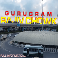
Rajiv Chowk Gurgaon: location, role and urban context
As an identifiable urban node, Rajiv Chowk Gurgaon typically refers to a traffic roundabout or square where multiple arterial roads meet, and where commercial activity concentrates. The site sits within the larger metropolitan framework of Gurugram (formerly Gurgaon), a rapidly expanding city in the state of Haryana that forms part of the National Capital Region (NCR). City planning, transport planning and private real estate investment together influence how this area functions day-to-day.
Geography and connectivity
Rajiv Chowk lies at the intersection of main thoroughfares that serve local neighbourhoods, office districts and feeder routes to larger highways. Road-based public transport (buses and shared vans), ride-hailing services and private vehicles are common. Pedestrian movement is significant in commercial pockets, so footpaths, crossings and last‑mile connections determine accessibility.
Urban role
The location serves local residents, office workers and shoppers. Small and medium retail, dining outlets and service providers cluster around the junction, while office buildings and mixed-use developments may be found on surrounding streets. This mix of uses makes Rajiv Chowk a microcosm of Gurugram’s broader urban dynamics: rapid commercial growth, changing mobility patterns and pressure on public infrastructure.
Transport, mobility and pedestrian environment
Public transport and connections
Transport options around Rajiv Chowk Gurgaon generally include city buses operated by state and local carriers, shared auto-rickshaws and app-based ride services. Bus routes connect the junction to nearby residential sectors and to regional corridors that lead toward Delhi and other parts of the NCR. Frequency and reliability vary by time of day and route.
Pedestrian and cycling considerations
Pedestrian infrastructure in many parts of Gurugram has been improving but remains uneven. Continuous pavements, safe street crossings and mapped cycle lanes are important for reducing short car trips and improving local air quality. For pedestrians, practical considerations include shaded walkways, wayfinding signs and clearly marked crossings at busy intersections.
Commerce, land use and the built environment
Retail and services
Retail activity near Rajiv Chowk typically ranges from small, independent shops and eateries to larger commercial establishments in nearby complexes. Service sectors—banking, healthcare clinics, and professional offices—also locate in the vicinity, supporting both residents and commuters.
Real estate and mixed use
Mixed-use development is a growing trend in Gurugram, where residential towers, office space and retail are combined to make efficient use of land. Land values near central nodes tend to be higher, which influences redevelopment pressure and the character of public spaces.
Governance, planning and public services
Planning authorities and regulations
Urban development and infrastructure improvements affecting Rajiv Chowk Gurgaon fall under local and regional agencies, such as the Gurugram Metropolitan Development Authority (GMDA) and the Municipal Corporation of Gurugram. These bodies are responsible for land-use decisions, road improvements, drainage and public amenities. Information about planning frameworks and major projects can be found through GMDA’s official resources.
Gurugram Metropolitan Development Authority (GMDA)
Public services and maintenance
Routine public services—street cleaning, lighting, waste collection and stormwater management—affect the everyday usability of public spaces around the junction. Coordination between municipal services and civic stakeholders helps maintain safety and sanitation in dense commercial corridors.
Quality of life, safety and accessibility
Safety and crowd management
High pedestrian and vehicle volumes at central junctions create safety challenges. Measures that improve safety include improved crosswalks, traffic-calming interventions, visible signage and enforcement of parking regulations. Local police traffic units and municipal enforcement bodies typically coordinate on peak-hour management.
Accessibility for all users
Accessibility measures—ramps, tactile paving, audible signals at crossings and reserved parking for persons with disabilities—support equitable access. Planning guidelines from national and state authorities set standards for accessible design, which local projects are encouraged to follow.
Practical tips for visitors and residents
Peak times and travel
Morning and evening peak hours see the highest traffic and pedestrian density. When possible, plan non-essential travel outside peak windows or use public transport routes that avoid the busiest corridors. Walking short distances can be faster than driving in congested stretches.
Finding services
Retail and essential services cluster near the junction; looking up local directories or municipal mappings can help identify specific services such as pharmacies, banks and clinics. Many residents rely on a mix of local shops and nearby commercial centers for daily needs.
Development outlook
Ongoing urban projects and policy changes will influence the junction’s future character. Attention to multimodal mobility, managed parking and public realm improvements are common priorities in local planning discussions.
Further reading and official sources
For authoritative guidance on regional planning and infrastructure investment, consult official publications and notices from the Gurugram Metropolitan Development Authority and the Municipal Corporation of Gurugram. Academic studies on urbanization in the National Capital Region also provide broader context on growth patterns and transport challenges.
FAQ
What is Rajiv Chowk Gurgaon and where is it located?
Rajiv Chowk Gurgaon refers to a central junction and commercial intersection within Gurugram, Haryana. Exact boundaries may vary in local usage, but the term commonly denotes a busy city node where several major roads converge and commercial activities concentrate.
How can one travel to Rajiv Chowk Gurgaon?
Travel options include city buses that serve nearby routes, shared autos and app-based ride services. Pedestrian access is common for nearby residents; where available, dedicated bus stops or drop-off points provide last-mile connectivity.
Who manages planning and improvements around Rajiv Chowk Gurgaon?
Planning and infrastructure improvements are managed by agencies such as the Gurugram Metropolitan Development Authority (GMDA) and the Municipal Corporation of Gurugram, supported by state-level urban planning frameworks and transport authorities.
Are there pedestrian facilities and accessible paths at Rajiv Chowk Gurgaon?
Pedestrian facilities vary by block and recent upgrades. Some stretches have continuous pavements, crossings and accessibility features, while other sections may need improvement. Municipal accessibility guidelines outline standards for ramps, tactile paving and crossing signals.
What changes are likely for Rajiv Chowk Gurgaon in coming years?
Potential changes include road upgrades, improved public-transport links, redevelopment of nearby parcels for mixed use and enhancements to pedestrian and cycling infrastructure as part of broader urban planning initiatives in Gurugram.