
BIM to GIS Data Conversion: Challenges, Workflows and Best Practices
-

- September 12th, 2026
- 1,851 views
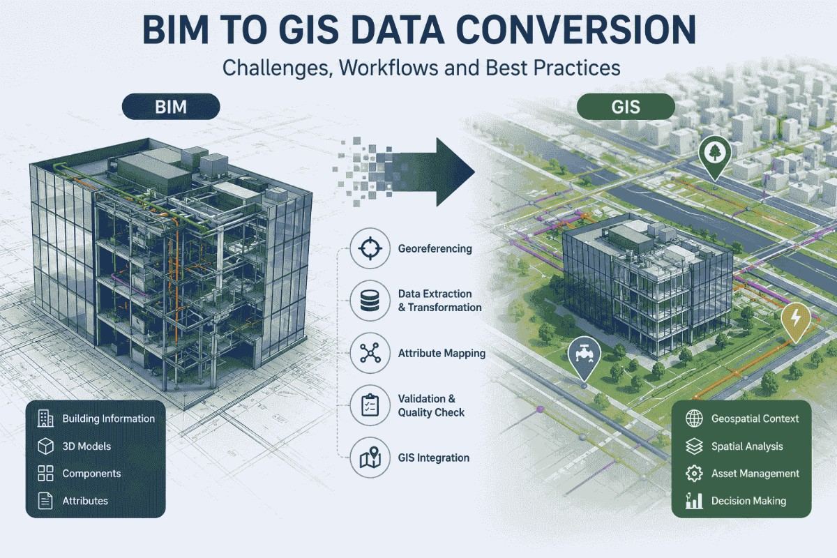
Modern infrastructure projects generate large volumes of digital information throughout their lifecycle. Building Information Modeling (BIM) provides detailed information about buildings, structures, components, and assets, while Geographic Information Systems (GIS) adds location-based intelligence to understand how these assets relate to their surrounding environment. Integrating these two technologies can provide a more complete view of infrastructure and support better planning, construction, and asset management.
BIM to GIS data conversion is the process of transforming BIM models and their associated information into geospatial data that can be used within GIS platforms. Although the concept appears straightforward, converting detailed BIM information into accurate and useful GIS data involves several technical challenges.
What Is BIM to GIS Data Conversion?
BIM models are primarily designed to represent the physical and functional characteristics of buildings and infrastructure. They can contain information about walls, doors, structural elements, mechanical systems, materials, dimensions, and other building components.
GIS, on the other hand, focuses on spatial relationships and geographic locations. By converting BIM data into GIS-compatible formats, organizations can place building and infrastructure information within a real-world geographic context.
For example, a BIM model of a commercial building can be integrated with GIS data containing roads, utility networks, terrain, property boundaries, transportation systems, and surrounding buildings. This creates a connected spatial environment for analyzing infrastructure at both building and city scales.
BIM to GIS Data Conversion Workflow
A structured workflow is essential for maintaining data accuracy and usability during conversion. A typical BIM to GIS workflow includes the following stages:
1. BIM Data Preparation
The first step is to review and prepare the BIM model. Unnecessary elements, duplicate information, and inconsistent attributes should be identified before conversion. The model should also be checked for geometry quality and completeness.
2. Coordinate System and Georeferencing
BIM models may use local project coordinates, while GIS platforms generally rely on geographic or projected coordinate reference systems. Therefore, the BIM model needs to be correctly positioned and georeferenced.
Accurate coordinate transformation is critical because even small positioning errors can affect infrastructure planning and spatial analysis.
3. Data Extraction and Transformation
Relevant BIM geometry and attributes are extracted and transformed into GIS-compatible structures. Depending on the project, information may be converted into formats such as GIS feature classes, 3D spatial datasets, or other interoperable formats.
During this stage, complex BIM objects may need to be simplified while retaining the information required for GIS analysis.
4. Attribute Mapping
BIM models contain extensive semantic information. GIS databases use their own attribute structures. Attribute mapping establishes relationships between BIM properties and GIS fields.
For example, information such as building component type, material, floor level, asset identification, and maintenance information can be mapped into appropriate GIS attributes.
5. Validation and Quality Checking
The converted dataset should be reviewed for geometry accuracy, coordinate alignment, missing attributes, duplicate features, and data inconsistencies. Visual comparison between the original BIM model and the GIS output can help identify conversion problems.
6. GIS Integration and Visualization
Once validated, the converted data can be integrated into GIS platforms alongside other geospatial datasets. Organizations can then visualize buildings and infrastructure within their broader geographic environment and perform spatial analysis.
Key Challenges in BIM to GIS Conversion
One of the major challenges is data interoperability. BIM and GIS use different data structures, standards, coordinate systems, and modeling approaches. Maintaining important information while moving data between these environments requires careful transformation.
Another challenge is geometry complexity. BIM models often contain highly detailed 3D objects designed for construction and engineering purposes. GIS applications may require simplified representations to improve performance and usability.
Coordinate system differences can also create significant problems. Incorrect georeferencing can result in BIM models appearing in the wrong geographic location or failing to align with existing GIS datasets.
Data volume is another consideration. Large BIM models can contain thousands or millions of objects and attributes. Converting and managing these datasets efficiently requires appropriate processing workflows and technical expertise.
Best Practices for BIM to GIS Data Conversion
Organizations can improve conversion quality by following several best practices:
Define the project requirements first: Identify which BIM elements and attributes are actually required for GIS applications.
Use appropriate data standards: Open and interoperable standards can improve compatibility between different platforms.
Maintain coordinate accuracy: Establish the correct coordinate reference system before conversion.
Preserve essential attributes: Avoid losing important asset information during data transformation.
Simplify geometry where necessary: Reduce unnecessary model complexity while retaining useful spatial information.
Perform quality assurance: Validate geometry, attributes, coordinates, and topology after conversion.
Document the workflow: Maintain records of transformations, mappings, standards, and validation procedures for future updates.
Applications of BIM-GIS Integration
BIM and GIS integration can support a wide range of applications, including smart city development, infrastructure management, urban planning, transportation planning, utility management, construction planning, and digital twin development.
For example, infrastructure managers can combine detailed BIM information about an asset with GIS data about surrounding roads, utilities, terrain, and land parcels. This allows teams to understand not only what an asset contains but also where it is located and how it interacts with nearby infrastructure.
Conclusion
BIM to GIS data conversion connects detailed building and infrastructure information with location-based intelligence. By combining BIM models with geospatial datasets, organizations can improve visualization, spatial analysis, infrastructure planning, and asset management.
Successful conversion requires more than simply changing one file format into another. Proper data preparation, georeferencing, attribute mapping, geometry transformation, interoperability, and quality assurance are essential for producing reliable GIS-ready datasets.
As digital twins, smart cities, and connected infrastructure continue to develop, effective BIM and GIS integration will become increasingly important for organizations seeking accurate, data-driven approaches to managing the built environment.