Digital Construction: The Rise of Scan to BIM Technology
-

- March 25th, 2026
- 3,788 views

FREE SEO Topical Map Generator: Find Your Next Content Ideas
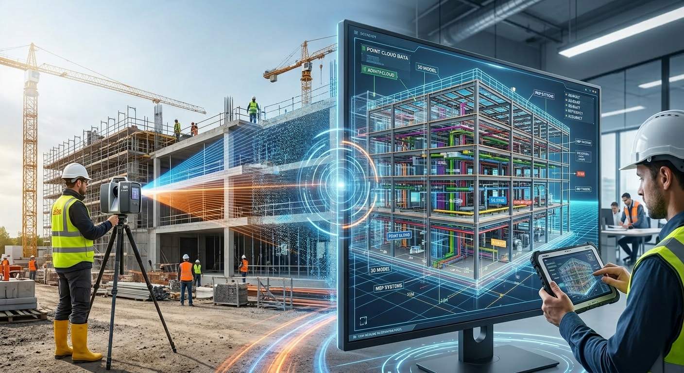
Digital construction technology changes how AEC construction industry managers document the built environment. Earlier site documentation relied on manual tape measurements, sketches, and fragmented survey notes. These methods produced inconsistent records. Modern project teams use automated spatial acquisition systems. These systems capture buildings as dense digital datasets. Teams integrate them into collaborative BIM environments for design coordination and engineering analysis.
Traditional surveying produced static two-dimensional drawings. These drawings introduced dimensional discrepancies across design and construction stages. Reality capture in construction now records sub-millimeter spatial measurements across entire building envelopes. It uses laser scanning and LiDAR sensors. These datasets move into parametric design platforms. Engineers analyze geometry. They evaluate structural alignments. They coordinate MEPF systems. This shift from manual documentation to automated spatial acquisition defines current digital construction workflows.
What Is Scan to BIM Technology and Why It Matters
A. The Core Technology Defined
Scan to BIM technology converts raw three-dimensional spatial measurements into Building Information Models. Laser scanners capture millions of coordinates. These coordinates describe surfaces, structural geometry, and system layouts within physical environments.
Processing software organizes these coordinates into structured point cloud datasets. BIM specialists interpret the spatial data. They construct parametric objects for architectural, structural, and MEP components within modeling platforms.
B. The Driving Industry Need
Many renovation and brownfield developments lack reliable construction documentation. Design teams working from outdated drawings face coordination conflicts, RFIs, and schedule disruptions. Verified spatial datasets from scanning workflows provide accurate references. These references guide engineering decisions.
C. Who Benefits Most
BIM Managers, VDC Directors, Structural Engineers, and MEPF coordinators gain strong operational value from scan-derived modeling workflows. Facility managers and asset owners also receive structured building data. This data supports maintenance planning and long-term asset lifecycle management.
How Scan to BIM Works in Modern Construction Projects
A. Site Control and Data Acquisition
Every Scan to BIM workflow begins with a unified coordinate framework. This framework governs spatial alignment across the dataset. Survey professionals deploy total stations or GNSS equipment. They define control points that anchor scan positions within a georeferenced grid. Technicians position LiDAR scanners across the facility. They follow a planned capture strategy. Each scanner records millions of spatial coordinates. These coordinates document architectural surfaces, structural members, and mechanical infrastructure.
B. Registration and Indexing
Processing software merges scan positions into a unified dataset. This process is called registration. Platforms such as Faro SCENE and Leica Cyclone Register 360 apply target or cloud to cloud alignment algorithms. They combine overlapping scans within a shared coordinate system. The consolidated point cloud undergoes segmentation, classification, and indexing. These steps organize spatial clusters and structural zones. The process converts raw measurements into structured RCP or RCS datasets. These datasets are ready for BIM authoring environments.
C. BIM Authoring and LOD Assignment
BIM specialists reconstruct building systems from the registered point cloud. They work in platforms such as Autodesk Revit. Modelers trace geometry from scanned data. They generate parametric objects for architectural components, structural assemblies, and MEPF infrastructure. Each element receives a Level of Development from LOD 300 to LOD 500. The assigned LOD defines geometric detail, embedded metadata, and quality checks.
Role of 3D Laser Scanning in Digital Construction
LiDAR Mechanics and Instrument Selection
3D laser scanning hardware forms the measurement backbone for digital construction workflows. LiDAR instruments emit laser pulses toward surfaces. They calculate spatial coordinates from return signal travel time or phase displacement. Each measurement forms a three-dimensional point. This point represents surface geometry. Modern scanners capture hundreds of thousands of points per second. They achieve millimeter precision. VDC teams select instruments based on project scale, interior density, environmental conditions, and required accuracy.
Time of Flight Scanners for Large Scale Environments
This scanner measures distance using the travel time of laser pulses. It works between the instrument and target surfaces. These scanners operate across long ranges. They exceed several hundred meters. They capture geometry across large facilities, bridges, and infrastructure corridors. Construction teams use Leica RTC360 or Faro X330 for large sites. Long range capability reduces the number of scan positions. It improves field productivity.
Mobile and Drone Scanning Platforms
Mobile scanning platforms and UAV mounted LiDAR systems expand spatial acquisition. Mobile systems mount on carts or vehicles. They record continuous measurements during movement through corridors, plants, or routes. Drone LiDAR platforms capture aerial views of large sites and infrastructure. These platforms speed up field acquisition. They cover areas where tripod scanning requires frequent repositioning.
Key Benefits of Scan to BIM for Architects and Engineers
High-Fidelity Spatial Accuracy: Laser scanning records millions of measurements. These measurements represent actual site geometry with millimeter precision. Architects and engineers evaluate dimensions, alignments, and clearances using verified spatial references.
- Improved Clash Detection Performance: BIM models from point cloud datasets provide accurate geometry for coordination workflows in platforms such as Autodesk Navisworks. Structural, architectural, and MEPF teams identify conflicts earlier.
- Reduced RFI Cycles During Construction: Field-verified models answer many coordination questions early. Contractors and consultants access accurate spatial references in the BIM environment. This reduces Requests for Information.
- Lower Construction Risk Across Renovation Projects: Verified spatial documentation reveals structural deviations, equipment constraints, and routing conditions before installation. Engineers plan modifications using reliable geometry.
- Accelerated Design Coordination and Project Delivery: Digital models from scan data support faster coordination. Design teams evaluate layouts, structural systems, and routing together in a shared BIM environment.
- Lifecycle Intelligence for Facility Management: 3D BIM models at LOD 400 or LOD 500 provide structured asset data. Owners use this data for maintenance planning, system tracking, and long-term decisions.
Applications of Scan to BIM in Renovation and Existing Buildings
A. Brownfield Project Documentation and Existing Condition Capture
Brownfield facilities contain undocumented alterations, relocations, and retrofits. These changes diverge from archived drawings. Detailed scan data reveals column deflection, slab irregularities, and envelope deviations. Engineers receive verified geometric conditions for assessment and design.
B. MEPF System Routing in Congested Ceiling Plenums
Mechanical ceiling plenums contain layered ductwork, conduit banks, cable trays, and pipe networks. These come from multiple renovation cycles. Point cloud to BIM conversion exposes system clearances and elevation offsets. Engineers design routing paths that avoid conflicts.
C. Heritage Building Preservation and Digital Twin Development
Historic structures contain irregular masonry, vaulted ceilings, and ornamental facades. They include nonorthogonal geometry. Traditional surveys struggle to capture these accurately. High-resolution scanning records these features as digital archives. It provides geometry for digital twin environments.
Challenges in Implementing Scan to BIM Workflows
Large infrastructure and renovation projects introduce operational and technical barriers. Scan to BIM challenges often come from massive point cloud datasets, hardware demands, strict LOD requirements, and interoperability issues across platforms.
- Massive point cloud datasets (.RCP / .RCS) require high-performance workstations and optimized storage systems
- High RAM, GPU acceleration, and NVMe SSD setups support efficient processing
- LOD 300 to 500 requirements increase detail, QA cycles, and model complexity
- Data exchange between Faro SCENE, Leica Cyclone, Autodesk ReCap, and Revit requires strict format control
- Skilled VDC specialists must manage scanning, processing, and BIM authoring workflows
- Occlusions, reflective materials, and complex geometry create field capture limits
Future of Digital Construction with BIM and Reality Capture
Artificial intelligence, SLAM-enabled mobile scanning, and digital twin ecosystems shape the next phase of digital construction technology. Autonomous capture systems collect spatial data during movement across facilities. This speeds up acquisition. Machine learning algorithms classify architectural, structural, and MEPF components from point cloud geometry. This reduces manual modeling effort. Digital twins connect BIM with IoT sensor networks. Facility operators monitor performance, predict maintenance, and improve decisions across the asset lifecycle.
Final thoughts: reality capture in construction
Reality capture in construction now acts as a core part of digital project delivery. High-precision LiDAR sensors and parametric BIM platforms convert physical environments into spatial intelligence. Engineers and VDC teams use this data to document conditions and guide coordination.
AEC organizations that integrate scan to BIM services into their workflows gain verified geometric data. This improves coordination accuracy. It reduces uncertainty in renovation planning. It strengthens lifecycle documentation. AI-driven modeling, SLAM capture, and digital twins continue to expand. Scanned spatial data will guide how engineers design, construct, and manage complex environments.